Sources: Crown Minerals / MBIE mineral permit database; GNS Science geological maps and geothermal resource assessments; NZ Petroleum & Minerals annual reviews. Resource estimates are order-of-magnitude figures; consult original survey reports before operational decisions.
Feasibility ratings: [A] = recoverable with pre-collapse infrastructure; [B] = recoverable with moderate effort/investment; [C] = technically possible but significant barriers; [D] = not realistically recoverable under near-term recovery conditions.
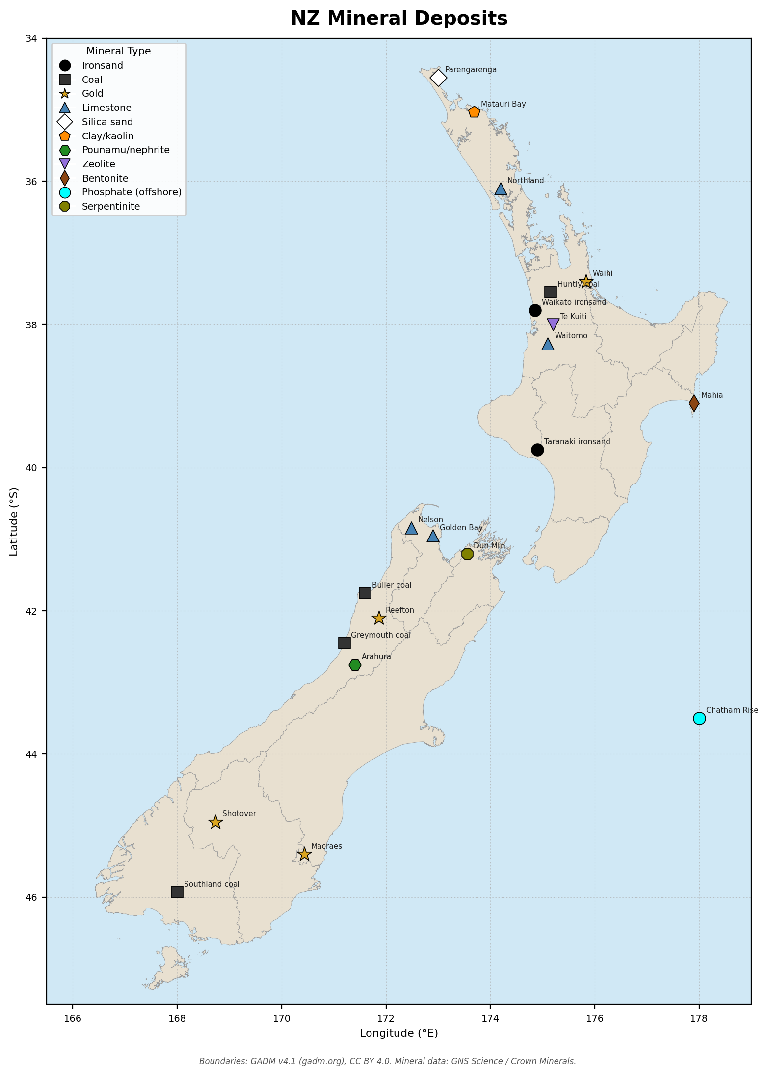
1. NZ Mineral Deposits
| Mineral | Location | Coordinates | Estimated Resource | Extraction Method | Current Status | Feasibility |
|---|---|---|---|---|---|---|
| Ironsand | Waikato West Coast (Raglan–Kawhia) | 37.80°S 174.85°E | ~1 billion t TiO₂-magnetite sands | Dredge + magnetic separation | Historically mined; NZ Steel Glenbrook still active | [A] |
| Ironsand | Taranaki (Patea–Whanganui coast) | 39.75°S 174.90°E | ~500 Mt estimated | Offshore/onshore dredge | Partially surveyed; no current extraction | [B] |
| Coal | West Coast — Buller (Westport area) | 41.75°S 171.60°E | ~600 Mt bituminous/sub-bituminous | Underground longwall & open cast | Active mines (Bathurst, Escarpment) | [A] |
| Coal | West Coast — Greymouth (Brunner etc.) | 42.45°S 171.20°E | ~300 Mt bituminous | Underground | Active (Solid Energy legacy; private operators) | [A] |
| Coal | Waikato (Huntly) | 37.55°S 175.15°E | ~100 Mt sub-bituminous | Open cast & underground | Huntly East residual extraction; Rotowaro active | [B] |
| Coal | Southland (Ohai–Nightcaps) | 45.93°S 168.00°E | ~200 Mt lignite/sub-bituminous | Open cast | Mothballed; large undeveloped lignite reserves | [B] |
| Gold | Coromandel (Waihi) | 37.40°S 175.83°E | Historic >7 Moz Au produced; Martha Mine active | Open pit + underground | Active — OceanaGold | [A] |
| Gold | West Coast — Reefton/Grey Valley | 42.10°S 171.86°E | ~1 Moz residual resource | Underground lode & alluvial | Active (Globe Progress, Blackwater) | [A] |
| Gold | Otago — Central Otago (Macraes) | 45.40°S 170.43°E | ~5 Moz Au (largest NZ hard-rock mine) | Open pit | Active — OceanaGold Macraes | [A] |
| Gold | Otago — alluvial (Arrow/Shotover) | 44.95°S 168.73°E | Diffuse alluvial; historically significant | Small-scale sluicing/dredge | Small artisanal operations; permitting constraints | [C] |
| Limestone | Whanganui / Taranaki (Golden Bay fringe) | 40.95°S 172.90°E | Very large — Ennis/Burnetts Face | Open quarry | Active cement & agri-lime production | [A] |
| Limestone | Northland (Matakohe–Otamatea) | 36.10°S 174.19°E | Large carbonate deposits | Open quarry | Active; Portland Cement NZ historic | [A] |
| Limestone | Nelson–Takaka (Marble Mt.) | 40.84°S 172.48°E | High-purity marble & limestone | Open quarry + underground | Active — Holcim/Takaka | [A] |
| Limestone | Waitomo / King Country | 38.27°S 175.10°E | Widespread karst; large agri-lime resource | Open quarry | Active at multiple sites | [A] |
| Silica sand | Parengarenga Harbour (Northland) | 34.55°S 173.00°E | ~43 Mt high-purity silica (>98% SiO₂) | Dredge | Active — Sibelco; glassmaking grade | [A] |
| Clay/kaolin | Matauri Bay / Northland kaolin | 35.03°S 173.69°E | ~2 Mt kaolin (halloysite) | Open pit | Active export — Imerys/Matauri; halloysite nanotechnology grade | [A] |
| Clay/kaolin | West Coast (Westport area) brick clay | 41.80°S 171.60°E | Widespread sedimentary clays | Open pit | Scattered small quarries | [B] |
| Aggregate | Auckland — Drury/Hunua greywacke | 37.10°S 174.97°E | Multiple large permitted quarries | Open quarry blasting | Active — multiple operators | [A] |
| Aggregate | Canterbury Plains — Waimakariri gravels | 43.45°S 172.45°E | Vast alluvial gravel resource | River extraction + pit | Active; environmental consent pressure | [A] |
| Pounamu/nephrite | West Coast — Arahura / Taramakau rivers | 42.75°S 171.40°E | Small — culturally irreplaceable | Hand/small-scale river recovery | Ngāi Tahu ownership; controlled harvest | [D] |
| Bentonite | Hawke’s Bay (Mahia / Wairoa) | 39.10°S 177.90°E | ~5 Mt estimated sodium bentonite | Open pit | Limited extraction; geological surveys incomplete | [C] |
| Zeolite | Northland — Te Kuiti / Otorohanga clinoptilolite | 38.00°S 175.20°E | ~20 Mt clinoptilolite zeolite | Open pit | Active — Zeolite NZ; agriculture/water treatment | [A] |
| Phosphate | Chatham Rise (offshore) | 43.50°S 178.00°E | ~36 Mt phosphorite nodules (seabed) | Deep-sea dredge (not yet developed) | EEZ resource; Chatham Rock Phosphate consent declined 2015 | [D] |
| Serpentinite | Nelson — D’Urville / Dun Mtn belt | 41.20°S 173.55°E | Large ultramafic belt; Ni, Cr trace | Open quarry (road metal historic) | No active mining; potential Ni/Cr source under recovery conditions | [C] |
Footnote 1: Ironsand resource figures from Crown Minerals NZ Minerals Programme 2023. Gold resource figures from NZX disclosures (OceanaGold) and GNS Science ore deposit database. Phosphate from Chatham Rock Phosphate prospectus and EPA decision (2015). Pounamu ownership vested in Ngāi Tahu under the Ngāi Tahu Claims Settlement Act 1998 — any recovery-era use requires Ngāi Tahu governance.1
2. Critical Mineral Gap Analysis
Minerals NZ does not produce in economically significant quantities and must stockpile or substitute. Annual consumption figures are approximate national estimates based on Statistics NZ trade data and industry reports.
| Mineral | Current NZ Source | Annual Consumption Est. | Strategic Importance | Substitution Options | Recommended Stockpile |
|---|---|---|---|---|---|
| Copper | Minor placer traces only; no economic deposit | ~60,000 t/yr (wire, plumbing, motors) | Critical — electrical infrastructure, motors, comms | Aluminium wire (higher gauge); recover from scrap; reduce; no true substitute for small-gauge wire | 5-year supply (~300,000 t); aggressive scrap recovery programme |
| Tin | None known | ~1,500 t/yr (solder, tinplate, bronze) | High — electronics solder, food-safe plating | Silver/bismuth solder (expensive); lead solder (toxic); zinc alloys for some uses | 10-year supply (~15,000 t); prioritise electronics-grade |
| Zinc | None economic | ~30,000 t/yr (galvanising, brass, die-cast) | High — corrosion protection of steel infrastructure | Aluminium or epoxy coatings; reduce galvanising specification | 5-year supply (~150,000 t); galvanising wire/sheet priority |
| Lead | None | ~8,000 t/yr (batteries, radiation shielding) | Moderate — lead-acid batteries for off-grid/vehicle storage | Lithium-ion (requires lithium); NiFe batteries; ultracapacitors | 3-year supply (~24,000 t); phase out non-battery uses |
| Aluminium (bauxite) | No bauxite deposits; smelter requires imported alumina | ~300,000 t/yr Al metal (Tiwai Pt. smelter + imports) | Very high — structural metal, electrical, packaging | Steel, timber, composites for structure; copper for electrical (limited); glass/ceramic for packaging | Tiwai Pt. closure severs domestic production; stockpile 2-year ingot reserve (~600,000 t Al) |
| Chromium | Trace in Dun Mtn serpentinite — sub-economic | ~5,000 t/yr (stainless steel, refractory) | High — stainless steel essential for food/medical equipment | Carbon steel with coatings; ceramic linings in refractories | 5-year supply (~25,000 t Cr metal/ferrochrome) |
| Manganese | No economic deposits | ~15,000 t/yr (steel deoxidiser, dry-cell batteries) | High — required in virtually all steel production | Partial substitution in some alloy grades; no substitute as deoxidiser | 5-year supply (~75,000 t MnO₂/ferromanganese) |
| Nickel | Trace in West Coast ultramafics — sub-economic | ~3,000 t/yr (stainless steel, batteries) | Moderate-high — stainless steel, EV batteries | Lower-alloy steels; cobalt substitute in some batteries | 5-year supply (~15,000 t Ni) |
| Lithium | None known | ~500 t/yr LCE (batteries, ceramics) | High and rising — energy storage critical for grid transition | NaS batteries; lead-acid; NiFe; flow batteries (vanadium) | 10-year supply (~5,000 t LCE); prioritise for grid storage |
| Rare earths | None economic | ~200 t/yr REO (magnets, catalysts, phosphors) | High — permanent magnets for wind turbines, EV motors, electronics | Wound-rotor induction motors avoid permanent magnets; ferrite magnets (weaker); reuse/recycle | 15-year supply (~3,000 t REO mix); focus on Nd, Dy for magnets |
| Sulfur | Volcanic sources (Whakaari/Rotorua) — small scale | ~40,000 t/yr (fertiliser superphosphate, chemicals) | Very high — superphosphate production requires H₂SO₄ | Limited: composted organic matter partially substitutes in soil; pyrite roasting if available | 5-year supply (~200,000 t elemental S); superphosphate plants to hold 2-yr H₂SO₄ reserve |
| Potash | None | ~200,000 t/yr K₂O equivalent (fertiliser) | Very high — pasture and crop nutrition; no adequate organic substitute at scale | Wood ash (low-grade K); composting; seaweed; crop rotation — all insufficient at scale | 10-year supply (~2,000,000 t KCl); highest-priority fertiliser stockpile |
Footnote 2: Consumption estimates derived from Statistics NZ overseas trade data (HS commodity codes) and MBIE energy and minerals statistics. Potash and sulfur figures are particularly critical — NZ superphosphate industry depends entirely on imported sulfur and rock phosphate. Tiwai Point aluminium smelter closure (scheduled 2024) ends domestic primary aluminium production.2
3. Aggregate and Building Stone — Major Quarry Locations
| Region | Location | Rock Type | Suitability |
|---|---|---|---|
| Northland | Matakohe quarry | Limestone | Agri-lime, road base, concrete aggregate |
| Northland | Maungaturoto area | Greywacke/argillite | Road metal, fill |
| Auckland | Drury (Stevenson) | Greywacke | Concrete aggregate, road base; high demand |
| Auckland | Hunua (multiple) | Greywacke/andesite | Crushed rock, armourstone |
| Waikato | Hamilton Basin | River gravel (Waikato R.) | Concrete aggregate; declining resource |
| Bay of Plenty | Tauranga area | Pumice/ignimbrite | Lightweight fill, insulation aggregate |
| Taranaki | Mt. Taranaki ring | Andesite lava | Roading, concrete; high quality |
| Hawke’s Bay | Napier–Hastings quarries | Greywacke | Road metal, concrete |
| Manawatū/Whanganui | Rangitīkei gravels | Mixed greywacke gravel | Concrete aggregate, roading |
| Nelson/Marlborough | Waimea plains | Greywacke/schist gravel | Concrete, road base |
| West Coast | Westport–Greymouth | Greywacke/granite | High-quality crushed rock; rail access |
| Canterbury | Waimakariri/Rakaia rivers | Greywacke gravel | Largest aggregate resource; Canterbury construction |
| Canterbury | Port Hills/Banks Pen. | Basalt (Lyttelton volcanic) | Premium concrete aggregate, armourstone |
| Otago | Dunedin — Leith/Kaikorai | Basalt/greywacke | Local concrete and road metal |
| Otago | Central Otago schist | Schist (Otago Schist) | Paving slabs, walling stone; limited crushing |
| Southland | Invercargill area | Alluvial gravel | Concrete aggregate; adequate regional supply |
| Southland | Fiordland margins | Granite/gneiss | High-quality crushed rock; remote access |
Footnote 3: Quarry locations and rock types from GNS Science QMAP geological map series and regional council aggregate surveys. River gravel extraction from Waikato and Canterbury rivers is increasingly consent-constrained; alternative hard-rock quarry capacity should be maintained.3
4. Geothermal Resources
All major fields are within the Taupō Volcanic Zone (TVZ) except Ngāwha (Northland). Temperatures are approximate reservoir values; wellhead temperatures vary. Current installed capacity ~1,000 MWe nationally.
| Field | Coordinates | Reservoir Temp. (°C) | Current Use | Expansion Potential |
|---|---|---|---|---|
| Wairakei | 38.63°S 176.08°E | 260 | 147 MWe generation (Contact Energy); direct heat | Moderate — reservoir management constraints |
| Kawerau | 38.09°S 176.71°E | 290 | 100 MWe generation; large industrial process heat (Norske Skog paper mill) | High — industrial heat demand can expand |
| Ohaaki (Broadlands) | 38.52°S 176.30°E | 270 | 22 MWe (Contact Energy); below design capacity | Moderate — reinjection improvements underway |
| Mokai | 38.55°S 175.97°E | 300 | 112 MWe (Tuaropaki Trust / Mercury) | Moderate — reservoir well characterised |
| Ngatamariki | 38.50°S 176.17°E | 310 | 82 MWe (Mercury NZ); high-temperature field | High — additional wells feasible |
| Rotokawa | 38.60°S 176.20°E | 330 | 143 MWe (Mercury NZ / Ngāti Tūwharetoa) | Moderate — near capacity |
| Te Huka / Tauhara | 38.75°S 176.10°E | 220 | 152 MWe Tauhara (Contact, opened 2023); expanding | High — Tauhara Stage 2 consented |
| Poihipi | 38.68°S 176.06°E | 240 | 55 MWe (Contact Energy) | Limited — peripheral to Wairakei field |
| Te Mihi | 38.66°S 176.09°E | 250 | 166 MWe (Contact Energy) | Moderate — recent development |
| Ngawha (Northland) | 35.45°S 173.82°E | 115 | 25 MWe (Top Energy); low-enthalpy field | Moderate — expansion to ~50 MWe planned |
| Rotorua urban field | 38.15°S 176.25°E | 150 | Direct use: bathing, space heating, tourism; no generation | Limited — urban constraints; protected bores |
| Taupo volcanic belt (undeveloped) | 38.69°S 175.77°E | 250 | Multiple untapped prospects (Horohoro, Tikitere, Reporoa) | High — significant undeveloped resource if grid infrastructure disrupted |
Footnote 4: Reservoir temperatures and installed capacity from GNS Science geothermal programme reports and generator company annual reports (Contact Energy, Mercury NZ, Top Energy). Geothermal generation contributes ~17% of NZ electricity; resilient to climate variability — a key post-disruption energy advantage.4
5. Volcanic Hazard Zones
Hazard radii indicate the primary risk zone (pyroclastic flows, lahars, ballistics, or surge depending on volcano type). Ashfall can extend hundreds of kilometres beyond these radii. The Taupō supervolcano hazard radius reflects potential national impact from a large (VEI 6+) eruption.
| Volcano | Coordinates | Type | Primary Hazard Radius (km) | Last Significant Eruption | Notes |
|---|---|---|---|---|---|
| Ruapehu | 39.28°S 175.57°E | Andesitic stratovolcano | 30 | 2007 (lahar 1995/96) | Largest NZ volcano; lahars reach Whanganui/Hawke’s Bay |
| Taranaki (Egmont) | 39.30°S 174.06°E | Andesitic stratovolcano | 40 | ~1790s | High lahar risk; ~130,000 people within 40 km |
| Whakaari (White Island) | 37.52°S 177.18°E | Wet hydrothermal/andesitic | 5 | 2019 | Offshore; tourist risk; no permanent population |
| Tongariro | 39.13°S 175.64°E | Andesitic complex | 15 | 2012 (Te Maari) | Te Maari crater active; lahars risk SH1/Desert Road |
| Ngauruhoe | 39.16°S 175.63°E | Andesitic cone | 10 | 1975 | Part of Tongariro complex; lava/ash |
| Rotorua caldera | 38.15°S 176.25°E | Rhyolitic caldera | 20 | ~1315 (Tarawera proximal) | Hydrothermal unrest ongoing; city sits on caldera |
| Tarawera | 38.22°S 176.51°E | Rhyolitic fissure/dome | 30 | 1886 | 1886 eruption killed ~120 people; rift extends under lake |
| Okataina caldera | 38.12°S 176.50°E | Rhyolitic caldera | 25 | 1886 (Tarawera vent) | Part of TVZ; high eruption potential |
| Taupo caldera | 38.80°S 175.89°E | Rhyolitic supervolcano | 100 | ~232 CE (Hatepe) | Largest Holocene eruption globally; regional ashfall risk |
| Mayor Island (Tuhua) | 37.28°S 176.25°E | Peralkaline rhyolite | 5 | ~6,340 yr BP | Offshore; low immediate risk; obsidian source |
| Auckland Volcanic Field | 36.87°S 174.76°E | Monogenetic basaltic | 5 | ~550 CE (Rangitoto) | ~53 vents; next eruption anywhere in AVF; city risk |
Footnote 5: Hazard radii from GNS Science volcanic hazard models and National Hazards Centre reports. Auckland Volcanic Field represents a unique planning challenge — the next eruption could occur at any location within the ~360 km² field. Taupō has erupted at VEI 8 (Oruanui, ~26,500 BP) and VEI 7 (Hatepe, ~232 CE); a repeat would be a civilisation-scale event for the Southern Hemisphere.5
Crown Minerals Act 1991; GNS Science Mineral Deposit Database; OceanaGold NZX disclosures 2023; Ngāi Tahu Claims Settlement Act 1998; Chatham Rock Phosphate EPA Decision EPBC 2012/0635.↩︎
Statistics NZ Overseas Merchandise Trade, HS codes 26–28, 31, 75–81 (2022 calendar year); MBIE Energy in NZ 2023; Rio Tinto Tiwai closure announcement.↩︎
GNS Science QMAP 1:250,000 geological map series; Auckland Council aggregate demand study 2021; Environment Canterbury aggregate resources review 2019.↩︎
GNS Science geothermal programme annual report 2023; Contact Energy generation portfolio report 2023; Mercury NZ annual report 2023; Top Energy Ngāwha geothermal project.↩︎
GNS Science volcanic hazard models (Volcanic Alert Levels); National Emergency Management Agency volcanic hazard guides; Wilson et al. (2009) Taupō eruptive history, J. Volcanology; Auckland Volcanic Field hazard assessment, GNS Science 2020.↩︎