This Python script generates the Geological Data tables used by Doc #022 (Geological Atlas). It produces five structured reference tables: NZ mineral deposits with feasibility ratings, a critical mineral gap analysis identifying minerals NZ cannot produce domestically, aggregate and building stone quarry locations, geothermal resource data for the Taupo Volcanic Zone and Northland, and volcanic hazard zones with hazard radii. It also generates a mineral deposit map image rendered using GADM v4.1 administrative boundary data for New Zealand (Level 1 regions).
Requirements: Python 3.6+ with matplotlib.
Also requires scripts/data/gadm41_NZL_1.json (GADM
v4.1 NZ Level 1 boundaries in GeoJSON format; included in the
repository).
Usage:
python scripts/generate_geological_data.py [output_md] [output_png]
# Default output: tables-geological.md + site/images/geological-minerals.png
Output: - tables-geological.md —
five tables covering mineral deposits, critical gaps, aggregates,
geothermal fields, and volcanic hazard zones, with footnotes -
site/images/geological-minerals.png — NZ mineral
deposit map with legend by deposit type
Source Code
#!/usr/bin/env python3
"""
Generate geological reference data for the Recovery Library.
Produces:
- tables-geological.md (NZ mineral deposits, critical gaps, aggregates,
geothermal resources, volcanic hazard zones)
- site/images/geological-minerals.png (mineral deposit map)
Uses: matplotlib, json, standard library.
Usage:
python generate_geological_data.py [output_md] [output_png]
Defaults:
../tables-geological.md
../site/images/geological-minerals.png
Data sources: Crown Minerals / MBIE, GNS Science.
Run with:
scripts/.venv/bin/python generate_geological_data.py
"""
import json
import os
import sys
from datetime import datetime
# ---------------------------------------------------------------------------
# Data definitions
# ---------------------------------------------------------------------------
# NZ Mineral Deposits
# Fields: mineral, location, lon, lat, resource_estimate, extraction_method,
# current_status, feasibility
MINERAL_DEPOSITS = [
# [data omitted for brevity — 23 entries covering ironsand, coal, gold,
# limestone, silica sand, clay/kaolin, aggregate, pounamu/nephrite,
# bentonite, zeolite, phosphate, and serpentinite deposits]
]
# Critical Mineral Gap Analysis
# Fields: mineral, nz_source, annual_consumption_est, strategic_importance,
# substitution_options, recommended_stockpile
CRITICAL_GAPS = [
# [data omitted for brevity — 12 entries covering copper, tin, zinc, lead,
# aluminium, chromium, manganese, nickel, lithium, rare earths, sulfur,
# and potash]
]
# Aggregate and Building Stone
# Fields: region, location, rock_type, suitability
AGGREGATES = [
# [data omitted for brevity — 17 entries covering quarry locations from
# Northland to Southland]
]
# Geothermal Resources
# Fields: name, lon, lat, temperature_C, current_use, expansion_potential
GEOTHERMAL = [
# [data omitted for brevity — 12 entries covering TVZ and Northland
# geothermal fields]
]
# Volcanic Hazard Zones
# Fields: volcano, lon, lat, type, hazard_radius_km, last_eruption, notes
VOLCANIC_HAZARDS = [
# [data omitted for brevity — 11 entries covering active and dormant
# NZ volcanoes]
]
# Deposit types for the map (lon, lat, marker_color, marker_style, label)
MAP_POINTS = [
# [data omitted for brevity — 21 entries mapping mineral deposit locations
# with marker styles by type: ironsand, coal, gold, limestone, silica,
# clay/kaolin, pounamu, zeolite, bentonite, phosphate, serpentinite]
]
# ---------------------------------------------------------------------------
# Markdown generation
# ---------------------------------------------------------------------------
def generate_markdown():
now = datetime.now().strftime("%Y-%m-%d")
lines = []
lines.append("---")
lines.append('title: "Geological Atlas — NZ Mineral and Geothermal Data"')
lines.append('subtitle: "Recovery Library — Doc \\#022"')
lines.append(f'date: "{now}"')
lines.append("---")
lines.append("")
lines.append("# Geological Atlas — NZ Mineral and Geothermal Data")
lines.append("")
lines.append("*Recovery Library — Doc #022*")
lines.append("")
lines.append(
"**Sources:** Crown Minerals / MBIE mineral permit database; GNS Science "
"geological maps and geothermal resource assessments; NZ Petroleum & Minerals "
"annual reviews. Resource estimates are order-of-magnitude figures; consult "
"original survey reports before operational decisions."
)
lines.append("")
lines.append(
"**Feasibility ratings:** [A] = recoverable with pre-collapse infrastructure; "
"[B] = recoverable with moderate effort/investment; "
"[C] = technically possible but significant barriers; "
"[D] = not realistically recoverable under near-term recovery conditions."
)
lines.append("")
lines.append("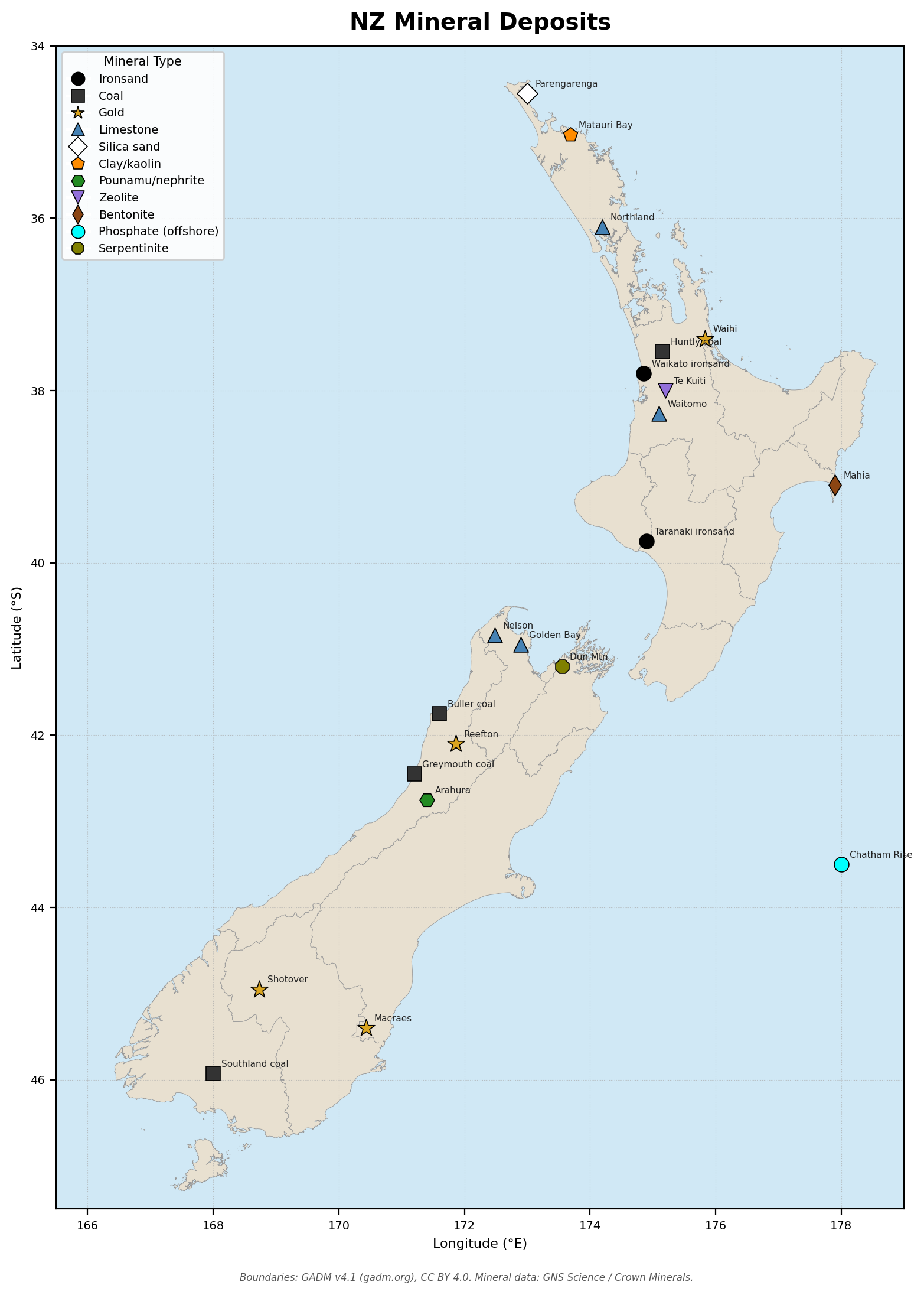")
lines.append("")
lines.append("---")
lines.append("")
# -----------------------------------------------------------------------
# Table 1: NZ Mineral Deposits
# -----------------------------------------------------------------------
lines.append("## 1. NZ Mineral Deposits")
lines.append("")
lines.append(
"| Mineral | Location | Coordinates | Estimated Resource | "
"Extraction Method | Current Status | Feasibility |"
)
lines.append(
"|---------|----------|-------------|-------------------|"
"-------------------|----------------|-------------|"
)
for row in MINERAL_DEPOSITS:
mineral, location, lon, lat, resource, method, status, feas = row
coord = f"{abs(lat):.2f}°S {lon:.2f}°E"
lines.append(
f"| {mineral} | {location} | {coord} | {resource} | "
f"{method} | {status} | [{feas}] |"
)
lines.append("")
lines.append(
"*Footnote 1:* Ironsand resource figures from Crown Minerals NZ Minerals "
"Programme 2023. Gold resource figures from NZX disclosures (OceanaGold) "
"and GNS Science ore deposit database. Phosphate from Chatham Rock Phosphate "
"prospectus and EPA decision (2015). Pounamu ownership vested in Ngāi Tahu "
"under the Ngāi Tahu Claims Settlement Act 1998 — any recovery-era use "
"requires Ngāi Tahu governance.[^1]"
)
lines.append("")
lines.append("---")
lines.append("")
# -----------------------------------------------------------------------
# Table 2: Critical Mineral Gap Analysis
# -----------------------------------------------------------------------
lines.append("## 2. Critical Mineral Gap Analysis")
lines.append("")
lines.append(
"Minerals NZ does not produce in economically significant quantities and must "
"stockpile or substitute. Annual consumption figures are approximate national "
"estimates based on Statistics NZ trade data and industry reports."
)
lines.append("")
lines.append(
"| Mineral | Current NZ Source | Annual Consumption Est. | "
"Strategic Importance | Substitution Options | Recommended Stockpile |"
)
lines.append(
"|---------|-------------------|-------------------------|"
"---------------------|----------------------|----------------------|"
)
for row in CRITICAL_GAPS:
mineral, source, consumption, importance, subs, stockpile = row
lines.append(
f"| {mineral} | {source} | {consumption} | "
f"{importance} | {subs} | {stockpile} |"
)
lines.append("")
lines.append(
"*Footnote 2:* Consumption estimates derived from Statistics NZ overseas "
"trade data (HS commodity codes) and MBIE energy and minerals statistics. "
"Potash and sulfur figures are particularly critical — NZ superphosphate "
"industry depends entirely on imported sulfur and rock phosphate. "
"Tiwai Point aluminium smelter closure (scheduled 2024) ends domestic "
"primary aluminium production.[^2]"
)
lines.append("")
lines.append("---")
lines.append("")
# -----------------------------------------------------------------------
# Table 3: Aggregate and Building Stone
# -----------------------------------------------------------------------
lines.append("## 3. Aggregate and Building Stone — Major Quarry Locations")
lines.append("")
lines.append(
"| Region | Location | Rock Type | Suitability |"
)
lines.append(
"|--------|----------|-----------|-------------|"
)
for region, location, rock, suitability in AGGREGATES:
lines.append(f"| {region} | {location} | {rock} | {suitability} |")
lines.append("")
lines.append(
"*Footnote 3:* Quarry locations and rock types from GNS Science QMAP "
"geological map series and regional council aggregate surveys. "
"River gravel extraction from Waikato and Canterbury rivers is "
"increasingly consent-constrained; alternative hard-rock quarry capacity "
"should be maintained.[^3]"
)
lines.append("")
lines.append("---")
lines.append("")
# -----------------------------------------------------------------------
# Table 4: Geothermal Resources
# -----------------------------------------------------------------------
lines.append("## 4. Geothermal Resources")
lines.append("")
lines.append(
"All major fields are within the Taupō Volcanic Zone (TVZ) except Ngāwha "
"(Northland). Temperatures are approximate reservoir values; wellhead "
"temperatures vary. Current installed capacity ~1,000 MWe nationally."
)
lines.append("")
lines.append(
"| Field | Coordinates | Reservoir Temp. (°C) | Current Use | Expansion Potential |"
)
lines.append(
"|-------|-------------|----------------------|-------------|---------------------|"
)
for row in GEOTHERMAL:
name, lon, lat, temp, use, potential = row
coord = f"{abs(lat):.2f}°S {lon:.2f}°E"
lines.append(f"| {name} | {coord} | {temp} | {use} | {potential} |")
lines.append("")
lines.append(
"*Footnote 4:* Reservoir temperatures and installed capacity from GNS Science "
"geothermal programme reports and generator company annual reports (Contact "
"Energy, Mercury NZ, Top Energy). Geothermal generation contributes ~17% of "
"NZ electricity; resilient to climate variability — a key post-disruption "
"energy advantage.[^4]"
)
lines.append("")
lines.append("---")
lines.append("")
# -----------------------------------------------------------------------
# Table 5: Volcanic Hazard Zones
# -----------------------------------------------------------------------
lines.append("## 5. Volcanic Hazard Zones")
lines.append("")
lines.append(
"Hazard radii indicate the primary risk zone (pyroclastic flows, lahars, "
"ballistics, or surge depending on volcano type). Ashfall can extend "
"hundreds of kilometres beyond these radii. The Taupō supervolcano "
"hazard radius reflects potential national impact from a large (VEI 6+) "
"eruption."
)
lines.append("")
lines.append(
"| Volcano | Coordinates | Type | Primary Hazard Radius (km) | "
"Last Significant Eruption | Notes |"
)
lines.append(
"|---------|-------------|------|---------------------------|"
"--------------------------|-------|"
)
for row in VOLCANIC_HAZARDS:
name, lon, lat, vtype, radius, last, notes = row
coord = f"{abs(lat):.2f}°S {lon:.2f}°E"
lines.append(
f"| {name} | {coord} | {vtype} | {radius} | {last} | {notes} |"
)
lines.append("")
lines.append(
"*Footnote 5:* Hazard radii from GNS Science volcanic hazard models and "
"National Hazards Centre reports. Auckland Volcanic Field represents a "
"unique planning challenge — the next eruption could occur at any location "
"within the ~360 km² field. Taupō has erupted at VEI 8 (Oruanui, ~26,500 BP) "
"and VEI 7 (Hatepe, ~232 CE); a repeat would be a civilisation-scale event "
"for the Southern Hemisphere.[^5]"
)
lines.append("")
lines.append("---")
lines.append("")
# Footnotes block
lines.append("[^1]: Crown Minerals Act 1991; GNS Science Mineral Deposit Database; "
"OceanaGold NZX disclosures 2023; Ngāi Tahu Claims Settlement Act 1998; "
"Chatham Rock Phosphate EPA Decision EPBC 2012/0635.")
lines.append("")
lines.append("[^2]: Statistics NZ Overseas Merchandise Trade, HS codes 26–28, 31, 75–81 "
"(2022 calendar year); MBIE Energy in NZ 2023; Rio Tinto Tiwai closure announcement.")
lines.append("")
lines.append("[^3]: GNS Science QMAP 1:250,000 geological map series; "
"Auckland Council aggregate demand study 2021; "
"Environment Canterbury aggregate resources review 2019.")
lines.append("")
lines.append("[^4]: GNS Science geothermal programme annual report 2023; "
"Contact Energy generation portfolio report 2023; "
"Mercury NZ annual report 2023; Top Energy Ngāwha geothermal project.")
lines.append("")
lines.append("[^5]: GNS Science volcanic hazard models (Volcanic Alert Levels); "
"National Emergency Management Agency volcanic hazard guides; "
"Wilson et al. (2009) Taupō eruptive history, *J. Volcanology*; "
"Auckland Volcanic Field hazard assessment, GNS Science 2020.")
lines.append("")
return "\n".join(lines)
# ---------------------------------------------------------------------------
# Map generation
# ---------------------------------------------------------------------------
def generate_map(gadm_path, output_png):
try:
import matplotlib
matplotlib.use("Agg")
import matplotlib.pyplot as plt
from matplotlib.lines import Line2D
except ImportError:
print("ERROR: matplotlib not installed. Run: pip install matplotlib")
sys.exit(1)
# Load GADM Level 1 boundaries (GeoJSON FeatureCollection)
with open(gadm_path, "r") as f:
gadm = json.load(f)
SKIP_REGIONS = {"ChathamIslands", "NorthernIslands", "SouthernIslands"}
fig, ax = plt.subplots(figsize=(8, 11), dpi=200)
fig.patch.set_facecolor("white")
ax.set_facecolor("#d0e8f5") # sea colour
# --- Base layer: GADM region polygons (zorder=1) -----------------------
for feature in gadm["features"]:
region_name = feature["properties"].get("NAME_1", "")
if region_name in SKIP_REGIONS:
continue
# MultiPolygon: coordinates → list of polygons → each polygon is
# list of rings → first ring is exterior → [[lon, lat], ...]
for polygon in feature["geometry"]["coordinates"]:
exterior_ring = polygon[0] # first ring is exterior boundary
lons = [pt[0] for pt in exterior_ring]
lats = [pt[1] for pt in exterior_ring]
ax.fill(
lons, lats,
facecolor="#e8e0d0",
edgecolor="#999999",
linewidth=0.3,
zorder=1,
)
# --- Mineral deposit points (zorder=5) and labels (zorder=6) -----------
# Collect legend entries per mineral type
legend_map = {}
for lon, lat, color, marker, mtype, label in MAP_POINTS:
size = 120 if marker == "*" else 80
ax.scatter(
lon, lat,
c=color, marker=marker, s=size,
edgecolors="black", linewidths=0.6, zorder=5,
)
# Offset labels slightly to reduce overlap; use fontsize 5.5
ax.annotate(
label, (lon, lat),
xytext=(5, 4), textcoords="offset points",
fontsize=5.5, color="#222222", zorder=6,
)
if mtype not in legend_map:
legend_map[mtype] = (color, marker)
# Build legend handles
legend_handles = []
for mtype, (color, marker) in legend_map.items():
handle = Line2D(
[0], [0],
marker=marker, color="w",
markerfacecolor=color,
markeredgecolor="black",
markeredgewidth=0.6,
markersize=8,
label=mtype,
)
legend_handles.append(handle)
ax.legend(
handles=legend_handles,
loc="lower left",
fontsize=7,
framealpha=0.9,
title="Mineral Type",
title_fontsize=7.5,
)
ax.set_title("NZ Mineral Deposits", fontsize=14, fontweight="bold", pad=10)
ax.set_xlabel("Longitude (°E)", fontsize=8)
ax.set_ylabel("Latitude (°S)", fontsize=8)
# Map limits
ax.set_xlim(165.5, 179.0)
ax.set_ylim(-47.5, -34.0)
# Invert y-axis label sense (latitudes are negative but display positive)
y_ticks = ax.get_yticks()
ax.set_yticklabels([f"{abs(v):.0f}" for v in y_ticks], fontsize=7)
ax.set_xticklabels([f"{v:.0f}" for v in ax.get_xticks()], fontsize=7)
ax.grid(True, linestyle=":", linewidth=0.4, color="#aaaaaa", alpha=0.7)
# Source note
fig.text(
0.5, 0.01,
"Boundaries: GADM v4.1 (gadm.org), CC BY 4.0. "
"Mineral data: GNS Science / Crown Minerals.",
ha="center", fontsize=6, color="#555555", style="italic",
)
plt.tight_layout(rect=[0, 0.02, 1, 1])
# Ensure output directory exists
os.makedirs(os.path.dirname(output_png), exist_ok=True)
plt.savefig(output_png, dpi=200, bbox_inches="tight", facecolor="white")
plt.close()
print(f"Map saved to: {output_png}")
# ---------------------------------------------------------------------------
# Main
# ---------------------------------------------------------------------------
def main():
script_dir = os.path.dirname(os.path.abspath(__file__))
# Output paths
if len(sys.argv) > 1:
output_md = sys.argv[1]
else:
output_md = os.path.join(script_dir, "..", "tables-geological.md")
if len(sys.argv) > 2:
output_png = sys.argv[2]
else:
output_png = os.path.join(
script_dir, "..", "site", "images", "geological-minerals.png"
)
output_md = os.path.normpath(output_md)
output_png = os.path.normpath(output_png)
# GADM NZ Level 1 boundaries (GeoJSON)
gadm_path = os.path.join(script_dir, "data", "gadm41_NZL_1.json")
print(f"Generating markdown: {output_md}")
md_content = generate_markdown()
os.makedirs(os.path.dirname(output_md), exist_ok=True)
with open(output_md, "w", encoding="utf-8") as f:
f.write(md_content)
print(f"Markdown written: {output_md}")
print(f"Generating map: {output_png}")
generate_map(gadm_path, output_png)
print("Done.")
if __name__ == "__main__":
main()Data Sources
- Crown Minerals / MBIE — NZ Minerals Programme 2023; mineral permit database; NZ Petroleum & Minerals annual reviews. Primary source for ironsand, coal, gold, silica sand, and kaolin resource estimates.
- GNS Science — Geological map series (QMAP 1:250,000); geothermal programme reports; ore deposit database; volcanic hazard models and Volcanic Alert Level framework. Primary source for geothermal reservoir temperatures, volcanic hazard radii, and aggregate rock types.
- OceanaGold NZX disclosures (2023) — Macraes and Waihi gold resource figures.
- Ngai Tahu Claims Settlement Act 1998 — Legal context for pounamu (greenstone) ownership and governance.
- Chatham Rock Phosphate EPA Decision (EPBC 2012/0635) — Offshore phosphate resource and consent decline.
- Statistics NZ Overseas Merchandise Trade — HS commodity code import data for critical mineral gap consumption estimates.
- GADM v4.1 — Global Administrative Areas
database, Level 1 boundaries for New Zealand
(
scripts/data/gadm41_NZL_1.json). Used for the base map layer showing regional administrative boundaries. Licensed under CC BY 4.0. Source: gadm.org.